Understanding Topographic Maps: What Do They Show?
Table of Contents
- Introduction
- What Are Topographic Maps?
- The Importance of Reading Topographic Maps
- How to Read Topographic Maps
- Practical Applications of Topographic Maps
- Topographic Maps vs. Other Types of Maps
- Choosing the Right Topographic Map
- Crate Club: Elevating Your Outdoor Preparedness
- Conclusion
- Frequently Asked Questions (FAQ)
Introduction
Imagine planning an outdoor adventure without a reliable map. Picture yourself lost in a dense forest, unable to navigate your way out. That’s where topographic maps come into play. These essential tools not only guide outdoor enthusiasts but also serve various professionals, from urban planners to environmental scientists. Topographic maps provide a wealth of information that is crucial for understanding the landscape around us.
This blog post aims to explore the intricacies of topographic maps—what they show, how to read them, and why they are indispensable in tactical and survival scenarios. By the end, you will have a comprehensive understanding of topographic maps, how to utilize them effectively, and the role they play in enhancing your outdoor experiences. We will also discuss the importance of quality gear, like that offered by Crate Club, that can further prepare you for your adventures.
What Are Topographic Maps?
Topographic maps are detailed representations of the Earth's surface, showing both natural and manmade features. They employ contour lines to illustrate terrain elevation and landforms, making them vital for various applications such as hiking, camping, land-use planning, and emergency response.
Key Features of Topographic Maps
-
Contour Lines: The most distinct feature of topographic maps, contour lines connect points of equal elevation. These lines help depict the shape of the land:
- Close Lines: Indicate steep slopes.
- Wider Spacing: Suggest gentler hills or flat areas.
-
Scale: Topographic maps are available in various scales (e.g., 1:24,000), which indicate the ratio of distance on the map to the actual distance on the ground. Larger scales provide more detail, making them ideal for planning outdoor activities.
-
Symbols and Colors: Different symbols represent various features:
- Blue: Water bodies (rivers, lakes).
- Brown: Elevation features (mountains, hills).
- Green: Vegetation or forests.
- Black: Manmade structures (roads, buildings).
-
Grid System: Most topographic maps incorporate a grid system to aid navigation, allowing users to determine their coordinates easily.
Historical Context of Topographic Mapping
The process of creating topographic maps has evolved significantly over time. The U.S. Geological Survey (USGS) has been producing these maps since the late 19th century. Initially hand-drawn, modern topographic maps are created using advanced satellite technology and geographic information systems (GIS), ensuring greater accuracy and detail.
The Importance of Reading Topographic Maps
Understanding how to read topographic maps is crucial for anyone engaging in outdoor activities. Here are some scenarios where this knowledge is particularly beneficial:
Hiking and Backpacking
For hikers, topographic maps help plan routes by identifying elevations, slopes, and potential water sources. Knowing the terrain can significantly impact the difficulty of a hike. For instance, a steep ascent might require more time and energy, making it essential to prepare accordingly.
Camping
When selecting a campsite, topographic maps indicate flat areas away from water sources prone to flooding. They also show elevation changes, which can affect wind exposure and temperature.
Emergency Preparedness
In emergency situations, such as search and rescue operations, topographic maps provide rescuers with vital information about the landscape, ensuring efficient navigation through rugged terrains.
Urban Planning
City planners use topographic maps to assess land use, drainage patterns, and zoning regulations. Understanding the topography helps prevent issues like flooding and landslides.
How to Read Topographic Maps
Learning to read a topographic map is a skill that can enhance your outdoor experiences significantly. Here’s a step-by-step guide:
Step 1: Understand the Legend
The legend provides crucial information about the symbols and colors used on the map. Familiarizing yourself with the legend will help you interpret the features accurately.
Step 2: Identify Contour Lines
Examine the contour lines to understand the terrain:
- Determine the contour interval (the vertical distance between contour lines).
- Look for patterns in the contour lines to identify hills, valleys, and slopes.
Step 3: Use the Scale
The scale allows you to measure distances accurately. Use a ruler or a piece of string to measure the distance between two points and convert that to actual ground distance using the scale provided.
Step 4: Find Your Location
Use the grid system to find your coordinates. This is especially useful in an unfamiliar area, allowing you to pinpoint your location with precision.
Step 5: Plan Your Route
When planning a route, consider the terrain. Identify potential obstacles, such as steep climbs or water bodies, and plan accordingly to ensure a safe and efficient journey.
Practical Applications of Topographic Maps
Topographic maps are invaluable in various fields and activities. Let’s delve into some practical applications:
Outdoor Recreation
For outdoor enthusiasts, topographic maps are essential for planning activities like hiking, mountain biking, and rock climbing. They provide insights into elevation changes and trail conditions, enabling users to select routes that match their skill levels.
Environmental Conservation
Conservationists utilize topographic maps to identify areas for preservation. Understanding the terrain is crucial when assessing ecosystems and planning conservation efforts.
Military Operations
In military operations, topographic maps are indispensable for strategizing movements and understanding the terrain. They provide vital information about elevation changes, potential ambush sites, and routes for transport.
Surveying and Land Development
Surveyors rely on topographic maps to assess land for development projects. These maps help identify suitable locations for buildings, roads, and other infrastructure by analyzing the terrain’s characteristics.
Topographic Maps vs. Other Types of Maps
While topographic maps provide detailed information about elevation and terrain, it’s essential to understand how they compare to other map types:
1. Road Maps
Road maps focus on transportation routes, showing highways, roads, and city locations. They lack the detail on elevation and terrain that topographic maps offer.
2. Political Maps
These maps emphasize boundaries and political divisions, such as countries, states, and cities. They do not include topographical details.
3. Thematic Maps
Thematic maps focus on specific themes or topics, such as population density or climate data. While they can provide valuable data, they do not convey terrain information like topographic maps.
Choosing the Right Topographic Map
When selecting a topographic map for your needs, consider the following factors:
Scale
Choose a map that suits your activity. For detailed navigation, a larger scale (e.g., 1:24,000) is ideal, while smaller scales (e.g., 1:100,000) may suffice for broader planning.
Area of Interest
Ensure the map covers your intended area of exploration. The USGS offers a variety of maps that cater to different geographic regions.
Updates and Accuracy
Consider the map's publication date and ensure it reflects the most current data. The USGS regularly updates its topographic maps, making them reliable resources for navigation.
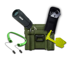
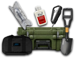
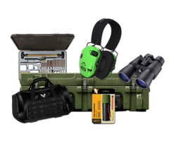
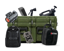
Crate Club: Elevating Your Outdoor Preparedness
At Crate Club, we understand the importance of being prepared for any situation while enjoying the great outdoors. Our subscription service offers curated tactical gear, survival tools, and equipment that can enhance your outdoor experiences.
Subscription Tiers
- Lieutenant Tier: Ideal for casual adventurers, this tier features essential survival and self-defense tools, EDC gear, and fire-starters at a value of $89 for just $49.99/month.
- Captain Tier: For those who want a mix of survival and tactical gear, the Captain tier offers high-quality tools and medical kits at a value of $153 for $99.99/month.
- Major Tier: For experienced survivalists looking for premium gear, the Major tier offers products worth $305 for $199.99/month.
- General Tier: Tailored for professionals, this tier includes real-issue tactical gear valued at $561 for $399.99 quarterly.
Explore our offerings at Crate Club Subscription Services to find the best fit for your outdoor needs.
Additionally, for those who seek specific gear, our Crate Club Shop provides a wide range of tactical tools and equipment.
Conclusion
Topographic maps are invaluable resources that provide essential information about the Earth's surface, aiding in navigation, planning, and decision-making across various sectors. Understanding how to read and utilize these maps can enhance your outdoor experiences, ensuring safety and preparedness in any situation.
As you embark on your next adventure, remember that quality gear from Crate Club can further empower your journey. By integrating topographic maps into your outdoor planning and equipping yourself with the right tools, you'll be well-prepared for whatever nature throws your way.
Frequently Asked Questions (FAQ)
What is the primary purpose of a topographic map?
The primary purpose of a topographic map is to illustrate the Earth's terrain, showing elevation changes and various natural and manmade features.
How do I read contour lines on a topographic map?
Contour lines connect points of equal elevation. Close lines indicate steep terrain, while spaced-out lines show flatter areas. The contour interval tells you the elevation difference between lines.
Can I use a topographic map for navigation while hiking?
Yes, topographic maps are excellent for navigation as they provide detailed information about the terrain, helping you plan routes and avoid obstacles.
How do I find a specific topographic map for my area?
You can obtain topographic maps from the USGS website or local outdoor retailers. Ensure you select a map that covers your area of interest.
Are digital topographic maps available?
Yes, many organizations, including the USGS, provide digital topographic maps that can be accessed online and printed if needed.
By mastering the art of reading and utilizing topographic maps, you can enhance your outdoor adventures significantly. Equip yourself with the right tools, stay prepared, and enjoy the great outdoors!
Share this article